Holiday and journey planning
Plan for your journey over holiday periods and long weekends using these resources, tips and tools.
Tools to plan your journey
Motorists are advised to plan their trip or consider using public transport during the NSW winter school holidays (Monday 8 to Monday 22 July) and the King’s Birthday public holiday falling on Monday 10 June, with increased traffic volumes expected across the state.
There is a suite of planning tools available to make it easier to plan your trip, avoid the busiest times on our roads, and reduce your overall journey time.
Journey planning tool
Our pinch point journey planning tool will help you avoid the busiest times on our roads by using historical data to show delay times observed at known pinch points around the state, during the same period in previous years.
It should be noted it is very difficult to precisely predict traffic delays. As such, the journey planning tool should act as a guide only to help you plan your journey.
Plan with the Live Traffic NSW app
Live Traffic NSW is the go-to app for commuters and holiday travellers seeking information about potential delays they might face on their trip.
The app and website provide real-time information about incidents and disruptions on the network. The Live Traffic app also gives customers the ability to receive notifications to their phone, alerting them about incidents and disruptions on their chosen route and time period.
Customers can choose to ‘follow’ individual incidents to receive notifications when the incident is updated or has ended.
By receiving notifications, road users can ‘set and forget’ and won’t have the hassle of constantly checking the app or site and means they can make the best decisions for their trip at the earliest opportunity. Learn more about the features by visiting the Live Traffic NSW.

0:38
Holiday and journey planning: Live Traffic App
Planning a snow holiday?
Before you head off to build a snow man, you need to make sure your car is prepared for alpine conditions. Our Tips for driving in the snow will help you build a pre-trip check list to ensure you get to the snow safely, including tips on how to correctly fit snow chains.
You can also subscribe to our SMS Alert service, to stay up to date when Kosciuszko Road or Alpine Way close due to parking at the ski fields reaching capacity.
Or sit back and relax and let Public Transport take you to the slopes with the Snowy Mountains Bus Service. The service takes passengers from Jindabyne to Perisher and Thredbo resorts 7 days a week, with connecting services via East Jindabyne, Tyrolean Village and Cooma, starting from 8 June to 6 October 2024.

0:34
Winter Holidays SMS Alert Service
What to expect these holidays
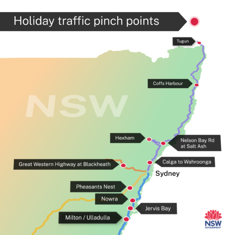
We anticipate traffic volumes and delays at known pinch points in Sydney and regional areas.
While difficult to predict, significant delays may occur at these locations, increasing the risk of incidents relating to driver frustration, fatigue and hazards caused by traffic queuing in high-speed zones.
Transport for NSW will have traffic management initiatives in place at the major known pinch points, but travellers should still be prepared to experience delays.
Motorists are reminded there is impacts to road networks following recent weather events. Before leaving on your holiday journey, we strongly recommend setting up your trip to receive real time updates with Live Traffic NSW on road conditions and possible delays.
Sydney
Sydney Airport
July is one of the busiest months of the year at Sydney Airport. If you’re heading interstate or overseas, allow extra travel time as the queues to get through airport security may be longer than usual. Parking is currently limited at the airport so it’s best to pre-book your parking ahead of time.
Plan your trip at transportnsw.info. If you’re driving, check livetraffic.com for the latest traffic updates before you leave home.
Regional NSW
The known Regional NSW pinch points are M1 Princes Motorway at Wahroonga, Hexham, Coffs Harbour, Tugun, Great Western Highway and the Princes Highway.
Great Western Highway
The Great Western Highway through the Blue Mountains can experience significant congestion during long weekends, school holidays and other special events. As during previous busy travel periods, Transport for NSW will work to help manage this congestion to minimise your travel delays and keep everyone safe on their journey through the mountains.
Learn more about how we manage congestion through the Blue Mountains.
Princes Highway
The Princes Highway from Nowra to Ulladulla can experience significant delays in peak periods. Visit the Princes Highway holiday congestion page to learn more about key Princes Highway pinch points and how to plan your journey to the beautiful NSW South Coast.
Kosciuszko Road and Alpine Way
Transport for New South Wales is required to temporarily close Kosciuszko Road or Alpine Way once parking availability at Perisher and Thredbo reaches capacity. While the road network is congested, we recommend you return to Jindabyne and take a break or consider alternative options such as public transport.
Have you mapped out your rest stops?
The Transport for NSW Rest Areas map allows you to view more than 500 Transport for NSW and council managed rest areas and highway service centres across the state. Making it the perfect tool to find a safe place to stop, rest and refresh yourself.
The interactive map is customisable, allowing you to find rest areas that suit your needs, including toilet facilities, a playground, BBQ’s, and/or wheelchair accessible facilities.
Tips for a safe journey
If you are planning to travel into regional NSW during a holiday period or long weekend, there is a number of simple steps you can take to make your journey as enjoyable as possible. These include:
- driving safely
- taking regular breaks and pre plan your driver reviver stops
- being patient
- being prepared for delays
- allowing extra travel time.
The Centre for Road Safety has some useful documents to help you prepare for a safe holiday, including:
You can also visit the follow resources to get further tips for safe journey:
- Live Traffic NSW: For the latest traffic information, download the Live Traffic NSW app or visit the website.
- Victoria traffic: Find information about road conditions for customers travelling into Victoria.
- Queensland traffic: Get information about road conditions for customers travelling into Queensland.
- Centre for Road Safety website: Get some helpful tips to avoid driving tired and other safe driving information.
- Latest public health orders at NSW Health
- NRMA website: For car maintenance tips and advice.
- NRMA Sloway: Are you taking your caravan on holidays and not in a hurry? NRMA has some tips for those customers looking to take their time to get to their destination.
- Rest areas in NSW: Use this interactive map to show you where you can safely stop, revive and survive.
- Electric vehicle charging map: Use this interactive map to help you plan your journey if you are travelling in an electric vehicle.
- NSW TrainLink bookings: Get to your destination on one of our regional trains or coaches.
- NSW SES: Get updates in the event of wet weather.
- Great Western Highway traffic congestion management
- Travelling on the Princes Highway
- Driving in the Snowy Mountains
- Sharing the road with trucks: See tips on how to be “truck aware” this summer holidays.